Surface Water Management

Global Menu

Surface Water Management

Public Works
Mill Creek Feasibility Study

If you would like to get information and updates in your inbox: emilyjd@co.skagit.wa.us.

Project Location

The project site is located on the south side of the Skagit River near Concrete, WA. The Mill Creek project area includes both Mill and Savage Creeks. Mill Creek is located on the South Skagit Highway at milepost 18.3. Mill Creek, a salmon bearing stream, historically flowed south to north, under the Mill Creek bridge, and into the Skagit River. The Mill Creek Basin, with its very steep gradient, transports vast amounts of sediment and large cobbles which has elevated the stream bed and reduced the available conveyance under the bridge, causing the creek to migrate within the alluvial fan, which South Skagit Highway bisects. Currently, South Skagit Highway overtops at this location an average of three times per year, and during the last seven years Mill Creek has avulsed annually, causing roadway damage and erosion along the west side sugar berm which threatens to let Mill Creek migrate entirely to the west.
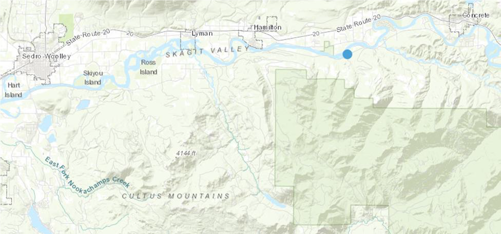
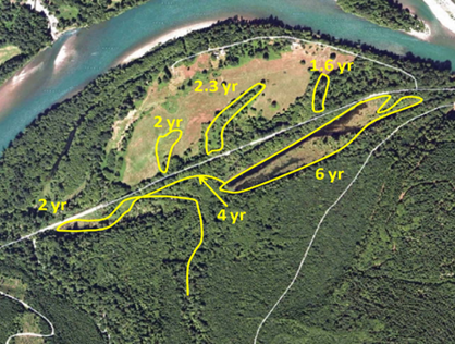

Project Location

Project History

In 2012, the Skagit River System Cooperative completed a Habitat Scoping Report evaluating the impacts of the highway on the Skagit River floodplain. This report identified over 60 acres of floodplain to be isolated by the road as well as 5.2 acres of wetlands and 21.7 acres of partially impacted fish habitat. You can find this report here.

In 2015, the Skagit River System Cooperative worked with Skagit County to identify four alternatives to improve habitat within the project area. Two alternatives left the road in place and added infrastructure to improve conveyance. This included raising the road and installing bridges (300 feet at Mill Creek and 50-105 feet at Savage Creek). The other two alternatives evaluated relocating the road out of the floodplain and out of the alluvial fan. At the time, the cost of each of the alternatives was between $10 and $17 million dollars (in 2015 dollars). The alternatives exceeded available funding for these types of projects and the project was shelved. You can find this report here.


Figure from HDR Submittal for Phase 1 showing existing road location, both creeks, and one of the 2015 alternatives.

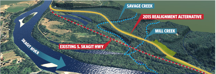
Mill Creek Feasibility Phase 1

Mill Creek Feasibility Study Phase 1
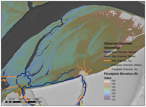
Figure from NHC Existing Conditions showing the Skagit River Floodplain

In 2023 Skagit County secured funding from the Washington State Department of Recreation and Conservation Office through their Salmon Recovery Funding Board (SRFB) and Puget Sound Energy to “dust off” the 2015 alternatives analysis. This funding is allowing the County to complete a much better survey of the area to find where new crossings should be. Current work includes:

  • Evaluation of previous alternatives
  • Updating survey to determine feasibility
  • Reselection of a preferred alternative
  • Advancement of at least conceptual design for the new crossings

Project Goals

The overall goals for this project include:

  • Improve habitat connectivity and floodplain processes for the benefit of threatened Puget Sound Chinook, Steelhead, and other salmon species.
  • Reestablish fish passage at Mill and Savage Creeks.
  • Increase climate change resiliency and reliability of the South Skagit Highway.
  • Reduce maintenance needs.
  • Reduce flooding.

Updates & Communications

2026

2025

2024

Reports

Documents

Project Partners and Stakeholders

Stakeholders and key partners in and near the project area will be involved throughout the project duration. The project will explicitly involve stakeholders and partners at key points during the decision-making process, including (but not limited to):

  • Alternative development and selection
  • Formation of the alternative selection criteria/decision matrix
  • Selection of a preferred alternative

Phase 1 Design Team

  • Skagit County Public Works
  • KPFF Consulting Engineers (KPFF)
  • Pacific Surveying & Engineering (PSE)
  • Northwest Hydraulic Consultants (NHC)
  • Aspect Consulting
  • Equinox Research and Consulting International (ERCI)

Stakeholders

  • City of Seattle 
  • Hampton Lumber 
  • McMillian Family 
  • Musgrave Revocable Trust & Musgrave John A/Diane W Trustees 
  • National Oceanic and Atmospheric Administration (NOAA) 
  • Puget Sound Energy 
  • Randal Family 
  • Sirios Timber Partners LP
  • Skagit River System Cooperative (SRSC)
  • Skagit Watershed Council
  • Skagit Fisheries Enhancement Group (SFEG)
  • Town of Concrete
  • Town of Birdsview
  • United States Army Corps of Engineers (USACE)
  • United States Fish and Wildlife Service (USFWS)
  • Upper Skagit Indian Tribe 
  • Washington Department of Fish and Wildlife
  • Washington State Department of Transportation (WSDOT) 

Current Funding Sources

  • Washington State Salmon Recovery Funding Board – more info here
  • Puget Sound Energy (PSE)
  • Skagit Conservation District 

Potential funding:

  • Brian Abbot Fish Barrier Removal Board (FBRB)
  • Bipartisan Infrastructure Law (BIL)
  • National Oceanic Atmospheric Administration (NOAA)
  • Local Programs
  • Seattle City Light 

FAQ’s

Why might a realignment be better than leaving the highway in place?
A realignment is a long-term solution that will address the road being within the Skagit River floodplain and the alluvial fan of two creek. Raising the road and bridges leaves it at risk for flooding and damage, costs almost the same as realignment, and would require maintenance. Realignment will also have benefits for fish habitat and salmon recovery, climate impacts, future flooding, and channel migration, making the project more competitive for funding.


Approximate frequency of flooding in areas surrounding South Skagit Highway. Source: TranTech Engineering LLC, March 31, 2015.

What are the next steps for this project?
As of early 2026 the County has identified a preferred alternative and begun collecting data to ensure the relocation is feasible. Next steps for this project include detailed survey downstream, cultural resource exploration, geotechnical work, and finalizing a design. We are continually looking for funding. We have secured funding through conceptual design and intend to have it completed by December 2026. We will be communicating and working with partners and interested parties throughout these processes.

When will construction for this project start?
We do not yet have an estimate for when construction will begin. Construction timing will depend on funding availability and the design process. The earliest possible construction would be 2030.

Contacts

Emily Derenne - Project Manager
360-416-1449
emilyjd@co.skagit.wa.us