Planning and Development Services

Global Menu

Planning and Development Services


Risk Assessment for the Skagit River Valley using HAZUS MH
Reports are available in Adobe PDF format.

Background

Risk Assessment Overview

A Revised Flood Insurance Study was completed by the United States Army Corps of Engineers (USACE) and has been issued as a preliminary Digital Flood Insurance Rate Map (DFIRM) by FEMA in June 2010. This study incorporated updated hydrologic and hydraulic analyses for the Skagit River and is summarized in the USACE report title "Skagit River Basin, Washington, Revised Flood Insurance Study, Hydraulics Summary" (See Additional Information). The USACE study followed FEMA Guidelines and Specifications for levee modeling (Appendix H, see additional information) and reflects a simulated removal of left and right bank levees and combines those results into a single depiction of the base (1 % annual chance) floodplain. The overall inundation area is a combination of 1-dimensional modeling (within the channel), and 2-dimensional modeling of the overbank using FLO-2D (numeric model). For this study the USACE modeled seven levee removal scenarios within the Skagit Basin. The levee removal scenarios modeled by USACE were used to create a depth grid, which is a raster image with each pixel having a value of flood depth derived from a given flood scenario (i.e. 1 % annual chance flood). For this study four levee scenarios created by USACE were used which include the removal of the 1.Burlington levee, 2. East Mount Vernon Levee, and 3. Combined Levee removal scenarios incorporating all seven levee removals completed by USACE. Each levee scenario is shown is shown by community on the main menu.

Flood Modeling

The Skagit River goes through the towns of Concrete, Conway, Hamilton, and Lyman and the cities of Sedro Woolley, Burlington, Mount Vernon, and La Conner some of which experienced flood damages recently in 1990, 1996, 2003 and 2006. The Skagit River Basin consists of agriculturalffarming and a population of approximately 40,000 people making the risk of flooding high. FEMA Region X chose to focus on the Skagit River by completing a Risk Assessment for the area which is presented here. FEMA uses HAZUS MH which is a computer program that calculates losses due to flooding. By using HAZUS we can determine which areas are at risk from flooding and use this information for emergency response, evacuations, and emergency planning. The total economic loss, residential substantial damage, displaced population, and debris generation were calculated using various levee scenarios for the 50 and 100 year floods. The analysis was done for the entire Skagit Basin including the cities of Mount Vernon and Burlington. HAZUS uses local data and depth grids created from hydrologic and hydraulic modeling. For more information on the modeling please select the Flood Modeling section below. HAZUS was updated with Skagit County parcel data for residential properties. By updating HAZUS data with local data the results have better accuracy. The HAZUS analysis is analyzed at a census block level, not a building level, therefore the total economic loss, residential substantial damage, displaced population, and debris generation will be shown at a census block level. The calculations shown in this report are only estimates and may differ from an actual flood event. For more information on how HAZUS calculates losses please see Additional Information.


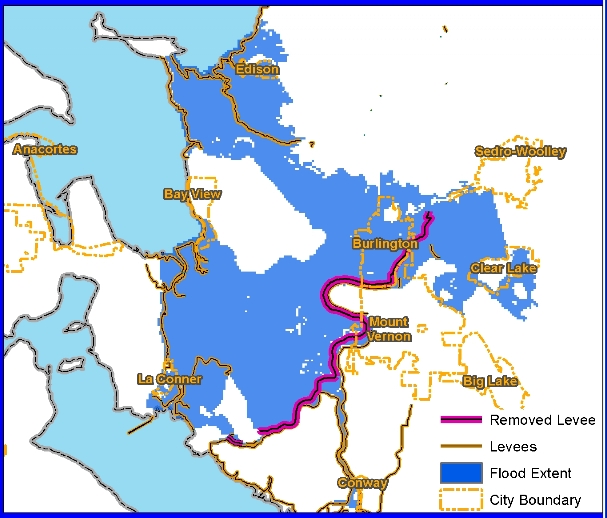
City of Burlington Report The analysis for the City of Burlington includes the removal of the right bank levees on the mainstem of the Skagit River and the North Fork Skagit River; keeping all other levees intact. The map to the right shows the levee removed in pink and the flooded area in blue. The entire length of the levee is removed for this scenario. Analysis was done using 50 and 100 year flood scenarios. In addition. essential facilities were identified in the City of Burlington which could be affected from flooding .

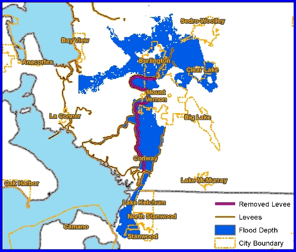
City of Mount Vernon Report

The analysis for the City of Mount Vernon includes the removal of the left bank levees on the mainstem of the south fork of the Skagit River, keeping all other levees intact. The map to the right shows the levee removed in pink and the flooded area in blue. The entire length of the levee is removed for this scenario. Analysis was done using 50 and 100 year flood scenarios. In addition, essential facilities were identified in the City of Mount Vernon which could be affected from flooding.

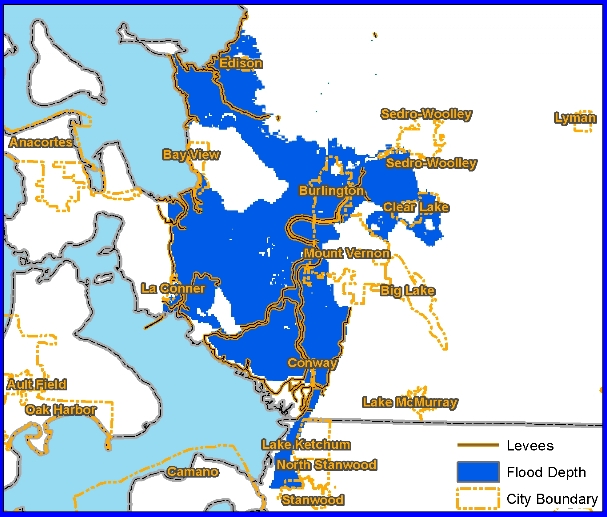
Skagit Valley Report

This analysis is for the entire Skagit Valley and includes a combination of seven levee removal scenarios. This scenario accounts for the removal of all the levees, shown in orange in the map to the right. This scenario is used for developing the 100 Year floodplain and represents many different flooding scenarios. Analysis was done using 50 and 100 year flood scenarios.

Additional Information

For more information please contact Kelly Durst FEMA region X


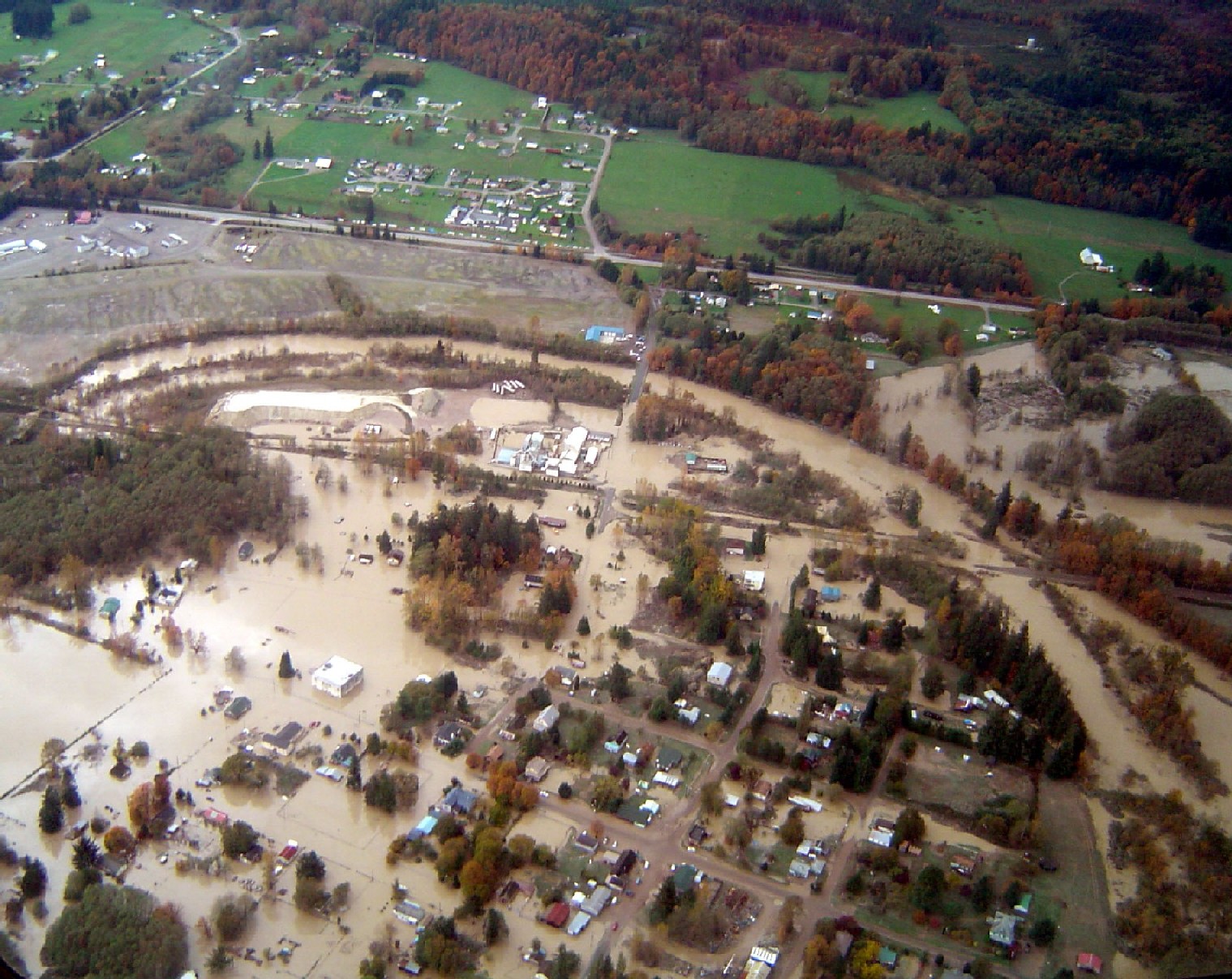
2003 Flooding: City of Burlington